July 21, 2026
Dulles, Reagan, and BWI are in thunderstorm ground stops as the East Coast locks Boston to Baltimore
Subscribe
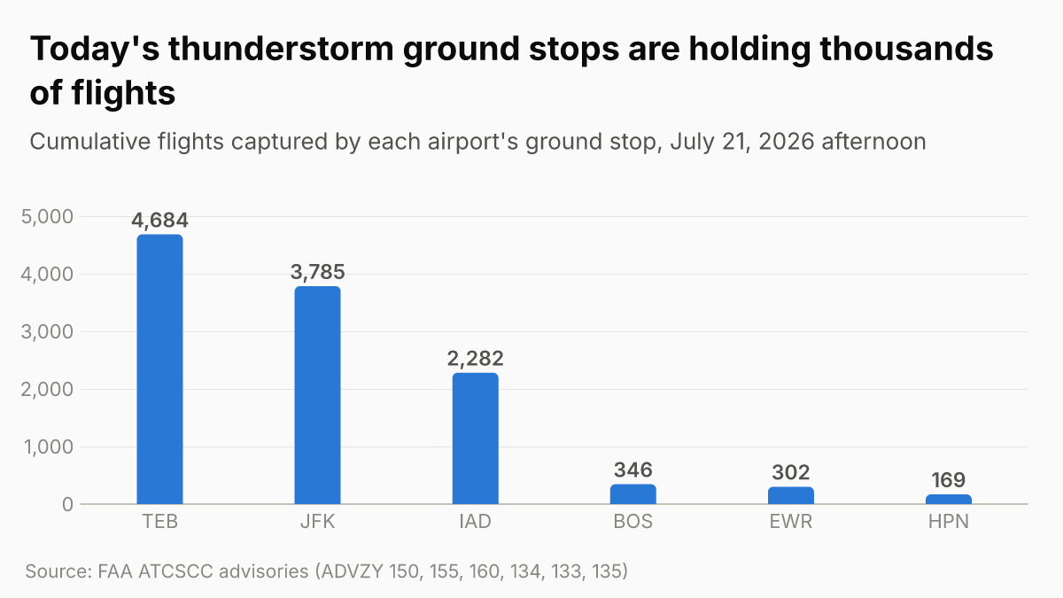
Dulles, Reagan, and BWI went into thunderstorm ground stops to 3 PM ET with Dulles holding 2,282 flights after the Potomac TRACON lost almost all departure routes, the New York metros re-entered ground stops to 3:30 PM with JFK holding 3,785 flights and GDPs running to midnight, Boston opened a ground stop plus a GDP to 10:59 PM, FlightAware counted more than 630 New York cancellations by early morning, American, United, Delta, and JetBlue all have East Coast rebooking waivers, and Tropical Storm Bertha's 2 PM advisory shows tropical-storm conditions spreading over the Florida Panhandle as the storm turns west toward Louisiana.
The DC metros just went into ground stops, and the Potomac TRACON has lost its routes
The convective wall that slammed New York at 8 AM kept marching south and reached Washington at lunchtime. By 2:10 PM ET all three DC-area airports are in thunderstorm ground stops: Dulles (IAD), Reagan National (DCA), and BWI, each posted to end at 3 PM ET.
Dulles is the severe one. Its CDM ground stop (FAA ADVZY 155, signed 1:33 PM ET) is holding 2,282 flights cumulatively with a 59-minute average and a HIGH probability of extension, and the advisory's comments are unusually blunt: "PCT has lost almost all departure routes. Significant surface impacts and throughput issues expected through 0100Z." That is 9 PM ET. In plain terms, the Potomac TRACON that works all three DC airports has almost no departure routes left to hand pilots, so the FAA is holding traffic on the ground and warning the mess runs well past the 3 PM stop time.
The FAA's operations plan (ADVZY 129) had flagged IAD, DCA, and BWI as "ground stop/delay program probable" through the afternoon, and a ZDC Severe Weather Avoidance Plan issued earlier had said DC metro departures "may experience delays due to weather." That precursor fired on schedule. Departures to Dulles are running 31 to 45 minutes behind on top of the stop.
New York re-entered ground stops, and the GDPs now run to midnight
Newark did not stay cleared. The ground stop that the 11 AM issue had ending at noon came back, and it brought LaGuardia and JFK with it. As of 2:10 PM ET, EWR, LGA, and JFK are all in thunderstorm ground stops posted to 3:30 PM, with ground delays averaging 3 hours 9 minutes at Newark, 3 hours 37 minutes at LaGuardia, and 2 hours 34 minutes at JFK.
Behind the stops, the ground delay programs are the long-running problem. Newark's GDP (ADVZY 132) now runs from 2 PM to midnight with a maximum delay of 665 minutes and a 189-minute average, and notes that the Cleveland Center departures "will remain in an internal stop until they have routes." JFK's ground stop (ADVZY 150) has swallowed 3,785 flights cumulatively, a 399-minute maximum, a 158-minute average, and a HIGH extension probability, with the cause stated as "lack of routes and throughput" and "thunderstorm impact expected to remain until after 0000Z" (8 PM ET). The operations plan carries Newark, JFK, and LaGuardia GDPs all the way to 0359Z, which is 11:59 PM ET.
Teterboro is the rawest number of the day. Its ground stop (ADVZY 160, to 3:30 PM) is holding 4,684 flights cumulatively with a 441-minute maximum and a HIGH extension probability, the advisory noting TEB is "already experiencing surface constraints due to lack of departure routes." White Plains (HPN) is in a ground stop to 3 PM holding 169 flights.
The cancellation toll is already large and still building. FlightAware counted more than 630 cancellations across the New York airports by 7 AM ET, more than a quarter of LaGuardia's departures, and that figure kept climbing through the morning as the afternoon ground-stop wave fired.
Boston and Philadelphia are now in the wall too
Boston, which the 11 AM issue had only in the "convective crosshairs," is now live. BOS is in a thunderstorm ground stop to 3 PM ET (ADVZY 134, 346 flights, 86-minute average, "lack of routes") and converts to a ground delay program running 2 PM to 10:59 PM ET (0259Z). Live ground delays at Boston are averaging 2 hours 46 minutes.
Philadelphia's GDP, which opened at 2 PM as flagged this morning, is now the active program, with ground delays averaging 2 hours 21 minutes and departure delays of 1 hour 31 to 1 hour 45 minutes. The operations plan keeps PHL in a GDP through midnight.
That puts the full East Coast, Boston through Baltimore, under simultaneous ground stops or delay programs at 2:10 PM ET: BOS, HPN, IAD, DCA, BWI, TEB, EWR, LGA, and JFK in stops, with PHL in a GDP. San Francisco continues its routine low-ceiling GDP (averaging 37 minutes) and Toronto opened a GDP as well.
Rebooking: four carriers now have East Coast waivers
The waiver map widened as the storm wall went wall-to-wall. If you are flying through the Northeast today, change fees are waived at all four major carriers, and the lists now include the DC airports:
- American Airlines (page current as of July 21): change fee waived for travel through BWI, BOS, JFK, LGA, EWR, PHL, IAD, DCA, and HPN.
- United Airlines "East Coast Thunderstorms": covers BOS, BWI, DCA, EWR, IAD, JFK, LGA, and PHL for July 21 travel (ticketed by July 19), rebook July 20 to 23 in the same cabin and cities, with change fees and fare differences waived.
- Delta Air Lines "Northeast U.S. Inclement Weather": covers BOS, BWI, DCA, EWR, HPN, IAD, JFK, LGA, and PHL.
- JetBlue: a broad waiver covering 11 Northeast and Mid-Atlantic airports (LGA, JFK, EWR, HPN, ISP, BOS, PHL, DCA, BWI, RIC, ORF) for travel through July 22, rebook through July 26 with no change fees or fare differences.
Confirm the exact rebook window on your carrier's page before you move anything, and keep the same origin, destination, and cabin to avoid a fare difference where one applies.
Tropical Storm Bertha reaches the Florida Panhandle and turns west
While the Northeast wrestles convection, Bertha has made contact with the coast. The NHC's 2 PM ET intermediate advisory (Advisory 9A) heads "Bertha beginning to turn westward" and reports "tropical storm conditions spreading over portions of the Florida Panhandle within the warning area." A National Ocean Service station at Panama City Beach is already reporting sustained winds of 42 mph with a gust to 49.
Bertha is 60 mph, 995 mb, drifting northwest at 5, centered about 90 miles southwest of Panama City and 125 miles southeast of Mobile. A Tropical Storm Warning runs from the Bay/Gulf County line in Florida to the Terrebonne/Lafourche Parish line in Louisiana, and a Watch extends west to the Vermilion/Cameron Parish line and over Metropolitan New Orleans, Lake Pontchartrain, and Lake Maurepas. The forecast track takes Bertha near or along the northern Gulf Coast over the next several days, with gradual weakening Wednesday through Friday and rainfall of 2 to 4 inches, isolated 6, through Thursday.
No Gulf Coast airport is in a ground stop yet, and no carrier has posted a Bertha-specific Gulf Coast waiver as of this advisory. Pensacola (PNS) and Panama City (ECP) are the airports in the warning area taking conditions now, with Mobile (MOB), Gulfport (GPT), and New Orleans (MSY) in line for Tuesday into Wednesday. The next complete NHC advisory is at 5 PM ET. When carriers do issue Gulf waivers, expect American, Delta, Southwest, and United to follow the same playbook they used for Tropical Storm Arthur in June, covering that PNS, ECP, MOB, GPT, MSY set.
That’s the reading for this issue.
- Boston Logan's ground stop extends to 6:15 PM and Denver enters a 100-minute ground delay as the Northeast storm siege eases Jul 22
- JetBlue cancels 872 flights in four days, still leading U.S. cancellations Jul 22
- JetBlue's crew-scheduling collapse stranded its pilots and canceled a quarter of Tuesday's flights Jul 22
- FAA reopens New York and DCA ground delay programs as Northeast ground stops clear Jul 22
Want the next one?
Every new Flight Disruptions Now issue by email. One tap to unsubscribe.