July 21, 2026
LaGuardia and Newark are in thunderstorm ground stops as New York's storm wall finally fires
Subscribe
The Northeast convective wall that fizzled for fourteen straight mornings finally fired on cue at the 8 AM ET window, putting LaGuardia and Newark in thunderstorm ground stops to 9 AM with LGA ground delays averaging three hours thirty-seven minutes and JFK averaging two hours thirty-four, Teterboro's published ground stop holds 268 flights with no routes available, the FAA's plan puts the Washington metros and San Francisco up next after 11 AM and Boston after 1 PM, and Tropical Storm Bertha is at 50 mph with a NOAA Hurricane Hunter investigating as tropical-storm conditions reach the northern Gulf Coast late today.
New York's storm wall finally fired, and LaGuardia is taking the worst of it
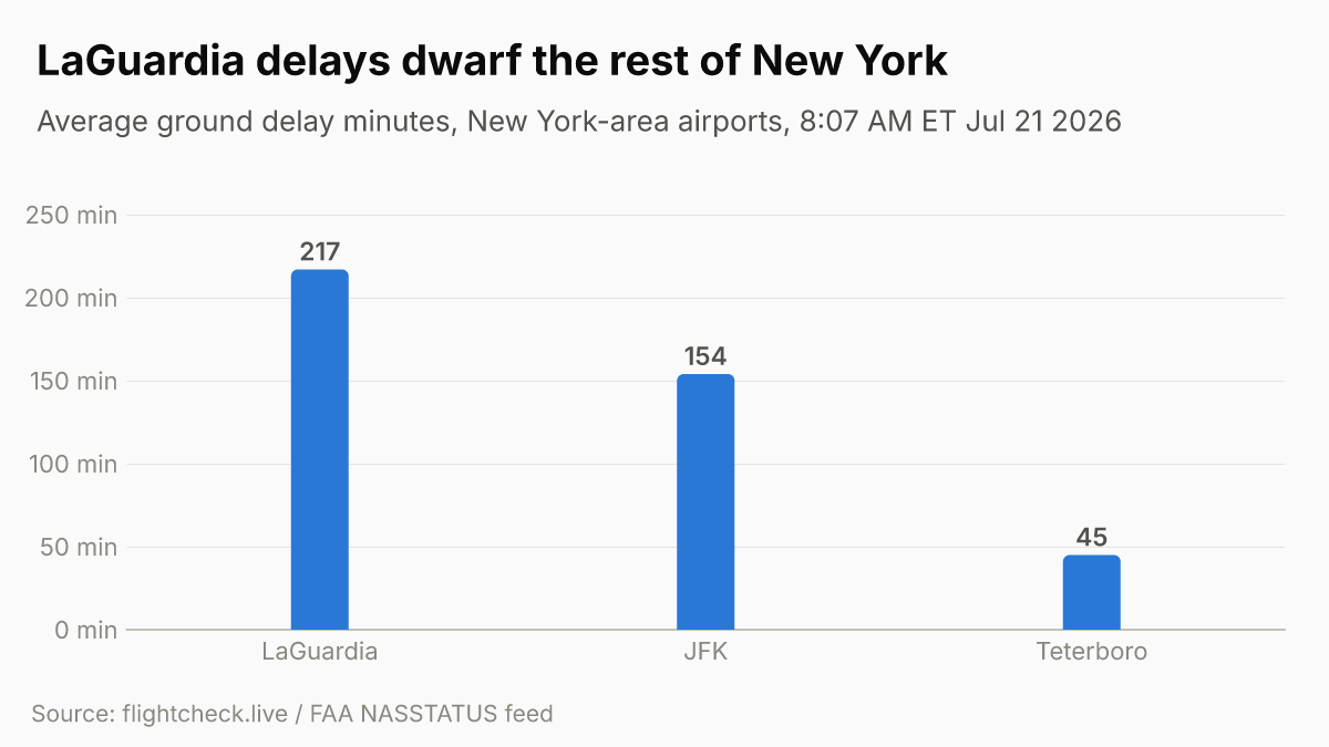
The FAA's morning operations plan, advisory 024 signed 4:24 AM ET, had tee'd up the whole Northeast for ground stops and delay programs "probable" after 8 AM ET, the same template that fizzled every morning since July 7. This morning it actually fired. By 8:07 AM ET, flightcheck.live (FAA NASSTATUS feed, last checked 12:07 GMT) showed LaGuardia and Newark both in thunderstorm ground stops scheduled to end at 9 AM ET, with LaGuardia ground delays averaging three hours thirty-seven minutes and JFK averaging two hours thirty-four. Philadelphia and Teterboro were posting 16-to-30-minute departure delays.
The formally published terminal stop is at Teterboro: FAA advisory 056, signed 8:09 AM ET, puts TEB in a CDM ground stop to 9 AM ET holding 268 flights with a 45-minute average and 55-minute maximum, medium extension probability, cause weather/thunderstorms, and the notation "NO ROUTES," meaning there was no available routing into the New York satellite airport at all. LaGuardia's program is the one that matters for most passengers: FAA advisory 040, signed 7:13 AM ET, is a CDM-proposed ground delay program for LGA arrivals from 9 AM ET through midnight, averaging 191 minutes with a 355-minute maximum, cause weather/thunderstorms, with confirmation expected after the 7:25 AM ET CDM conference. The three-hour-thirty-seven-minute LGA average on the live NASSTATUS feed is already running ahead of that proposal. The practical read for travelers: the LGA and EWR ground stops are short holds to 9 AM, but the LaGuardia ground delay program takes over at 9 AM and runs through midnight, so LGA stays in multi-hour delays all day even after the stop lifts.
Why it fired now: the FAA's plan called for a Northeast SWAP, the Severe Weather Avoidance Plan, as early as 6 AM ET at Potomac TRACON with the remaining New York terminals as early as 11 AM, and a Northeast regional planning discussion at 6:30 AM ET. Thunderstorms were already closing New York Center's oceanic route L454 (advisory 042, 7:19 AM ET) and Miami Center's Gulf routes Y280, Y290, Q100, and Q102 (advisory 055, 8:01 AM ET). Two weather reroutes were already active: SERMN_SOUTH_2 pushing New York departures to the Carolinas around the storms (advisory 035) and VLKNN_PARTIAL rerouting West Coast-to-Washington traffic around them (advisory 050). New York Center also extended flight-plan drop times to 180 minutes due to weather (advisory 030).
What's next: Washington metros and San Francisco, then Boston
The same operations plan that called today's New York stops puts the next wave on the clock. After 11 AM ET (1500Z), the FAA lists ground stops or delay programs as "probable" for the Washington metros, Dulles, Reagan National, and Baltimore, and for San Francisco, with Boston "probable" after 1 PM ET (1700Z). Denver is "possible" after 4 PM and an Atlanta ground stop "possible" after 5 PM. The 7:15 AM ET planning webinar has already run, so a sharpened operations plan should land within the usual two-to-three-hour lag, likely around 9 to 10 AM ET.
For passengers the practical read is that this is a forward-rolling convective day, not a single New York pulse. If you are connecting through Washington, San Francisco, or Boston later today, the same thunderstorm complex is forecast to reach those metros on the plan's schedule, and the New York delays will cascade into afternoon banks nationally as aircraft and crews displace. Atlanta, the world's busiest hub, is only a "possible" ground stop after 5 PM today, but it has fired on each of the last several convective afternoons and is the one to watch this evening.
Tropical Storm Bertha is at 50 mph and closing on the Gulf Coast
Tracking. Bertha is unchanged in track but firming in strength. NHC Intermediate Advisory 8A, issued 8 AM ET (700 AM CDT), puts the storm at 50 mph with a 997 mb central pressure, centered about 100 miles south-southwest of Panama City, Florida, and 175 miles southeast of Mobile, Alabama, moving northwest at 5 mph. A NOAA Hurricane Hunter aircraft is currently investigating the system. The Tropical Storm Warning, upgraded from a watch overnight, runs from the Alabama/Florida border to the Jefferson/Plaquemines Parish border in Louisiana, with a Storm Surge Watch for 2-to-4-foot surge from the Alabama/Florida border to the mouth of the Mississippi, and a Tropical Storm Watch now expanded to cover metropolitan New Orleans, Lake Pontchartrain, and Lake Maurepas.
The airport-relevant line from NHC: tropical-storm conditions are expected along the northern Gulf Coast warning area by late today into Wednesday, possible in the Florida Panhandle later today, and possible in Louisiana by late tonight. NHC forecasts some slight strengthening today before gradual weakening mid-week, and a track near or along the northern Gulf Coast over the next several days, with the next complete advisory at 11 AM ET. No Gulf Coast airport has gone into a ground stop or posted cancellations as of this morning, and no carrier has issued a Bertha-specific rebooking waiver yet. When Tropical Storm Arthur struck the Gulf Coast in June, American, Delta, Southwest, and United all issued penalty-free rebooking waivers; the same playbook is expected once warnings firmed, most likely covering Pensacola (PNS) and Panama City (ECP) first, then Mobile (MOB), Gulfport (GPT), and New Orleans (MSY) into Tuesday and Wednesday.
Rebooking basics
No Bertha-specific waiver has been posted yet, and the New York thunderstorm disruptions so far are running on standard weather-delay terms rather than a named waiver. If you are flying today, check your carrier's travel-alerts page directly: American, Delta, United, JetBlue, Southwest. Under the DOT refund rules in effect, if your flight is cancelled for any reason, including weather, you are entitled to a full cash refund if you decline the airline's alternative. When a waiver does drop, confirm you keep the same origin, destination, and cabin to avoid a fare difference.
That’s the reading for this issue.
- JetBlue cancels 872 flights in four days, still leading U.S. cancellations Jul 22
- JetBlue's crew-scheduling collapse stranded its pilots and canceled a quarter of Tuesday's flights Jul 22
- FAA reopens New York and DCA ground delay programs as Northeast ground stops clear Jul 22
- FAA cancels New York and Philadelphia GDPs as ground stops extend to 9 PM Jul 22
Want the next one?
Every new Flight Disruptions Now issue by email. One tap to unsubscribe.