July 18, 2026
LaGuardia is in a ground stop, Newark arrivals average nearly three hours, and the Northeast wall fired three hours ahead of the FAA's plan
Subscribe
The FAA's Saturday plan put the JFK/LGA and PHL/EWR/TEB wall at 2 p.m. ET. It went live before 10:30 a.m. LaGuardia has a ground stop to 11:30 a.m. with a ground-delay program behind it to 7:59 p.m., Newark is averaging 2 hours 55 minutes, Philadelphia and JFK are each near an hour and a half, and the DCA ground stop the FAA flagged as most likely for 8:30 a.m. fizzled again. The NWS rates the Northeast at an Enhanced Risk, level 3 of 5, for severe storms with damaging winds, a few tornadoes, and flash flooding, peaking 4 to 8 p.m., so the morning is likely the leading edge.
The Northeast wall went live three hours early
The FAA's current operations plan, advisory 092 (event time 18/1400Z and later, refreshed 9:50 a.m. ET), lists ground-delay programs implemented for all four Northeast hubs: JFK, LGA, EWR, and PHL. That is the same JFK/LGA plus PHL/EWR/TEB cluster this feed's 7:42 a.m. forecast had in the 2 p.m. ET window. It broke roughly three and a half hours early.
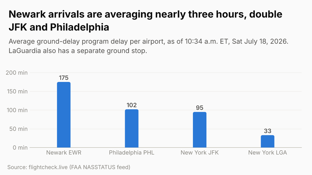
Live delay averages as of 10:34 a.m. ET, per the FAA-derived flightcheck.live feed:
- Newark (EWR): ground-delay program to 12:59 a.m. ET tonight, averaging 2 hours 55 minutes on thunderstorms. The longest program in the country.
- Philadelphia (PHL): ground-delay program to 10:59 p.m. ET, averaging 1 hour 42 minutes on thunderstorms and low visibility, plus departure delays of 1:01 to 1:15. Smoke is still a constraint here (see below).
- New York-Kennedy (JFK): ground-delay program to 10:59 p.m. ET, averaging 1 hour 35 minutes, plus departure delays of 1:01 to 1:15.
- New York-LaGuardia (LGA): a ground stop in effect to 11:30 a.m. ET, with a ground-delay program behind it running to 7:59 p.m. and departure delays of 1:31 to 1:45. LaGuardia is getting both measures at once.
- Teterboro (TEB): departure delays of 1:31 to 1:45; the FAA lists a TEB ground stop or delay program as possible after 11 a.m.
FlightAware counted 2,236 delays and 367 cancellations within, into, or out of the United States as of 10:44 a.m. ET. The cancellation count is already more than double Friday's 7:41 p.m. ET tally of 161, which suggests airlines are cutting flights proactively rather than letting a thinner Saturday schedule soak up multi-hour ground delays.
HOLDING DELAY ADVISORY ISSUED AND DIVERSION RECOVERY ACTIVATED FOR THE NORTHEAST AIRPORTS.
That is the FAA's own ops plan, advisory 092, and it means planes are already being diverted off the Northeast arrival streams. Escape routes (PHLYER_NORTH/SOUTH and SERMN_SOUTH_1) are active, and the Northeast airport diversion-recovery program runs to 10 p.m. ET.
The DCA ground stop fizzled. Again.
The single highest-confidence item in the FAA's Saturday plan was a DCA (Reagan National) ground stop expected after 8:30 a.m. ET. It did not fire. DCA is on time as of 10:34 a.m. ET, and so are IAD and BWI. This is the same morning-DCA template that fizzled on July 7, 8, and 9 even as July 17 verified hard. The lesson holds: on these convective mornings the plan's confidence ranking does not predict which airport actually gets hit first. Today the energy went north and east into the New York and Philadelphia corridor three hours ahead of schedule, and DCA was skipped. The FAA still lists BWI, DCA, and IAD ground stops or delay programs as possible after 2 p.m. ET, so DCA's day is not necessarily over.
Why: an Enhanced Risk severe-storm day, with smoke still in the mix
The cause is a severe-thunderstorm outbreak the NWS Mount Holly forecast office upgraded to an Enhanced Risk, level 3 of 5, for eastern Pennsylvania, New Jersey, Delaware, and the Delmarva. The hazards are damaging wind gusts of 50 to 70 mph (per NYC Emergency Management, via Gothamist), a few tornadoes, large hail, and flash flooding. A Flood Watch runs 10 a.m. Saturday through 2 a.m. Sunday along and northwest of the I-95 corridor, with rainfall rates of 2 to 3 inches per hour possible. Multiple rounds of storms are expected from late morning through midnight, and the NWS's worst window is roughly 4 to 8 p.m. ET.
That timing matters: the morning disruption is the leading edge, and the heaviest storms are forecast for the afternoon and early evening. AccuWeather puts roughly 55 million people in the severe-risk zone from eastern Ohio through Pennsylvania, New York, New Jersey, Maryland, Delaware, and northern Virginia. On Sunday the main threat shifts to the Carolinas and southern Virginia.
Canadian wildfire smoke is still compounding it. The FAA's ops plan lists PHL and PCT (Potomac) under a low-visibility and smoke terminal constraint, which is part of why Philadelphia's ground-delay program is running on top of its thunderstorm delays. NWS meteorologist Brian Ciemnecki told Gothamist that smoke drifted back into the New York area overnight and will linger through the first half of Saturday, with air quality rated unhealthy Saturday morning but improving through the day as rain scrubs it out.
A staffing layer sits underneath all of this. The FAA's ops plan has staffing triggers for ZNY (New York Center) Areas A and E until 1 p.m. ET, PHL Area C until noon, and D10, the Dallas TRACON, until 3 p.m. ET. With the controller shortage still roughly 3,000 below target (covered yesterday), there is less slack to clear the backlog between storm cells, which is part of why recovery on these days keeps spilling past midnight.
Rebooking: Delta's NYC waiver covers today
Delta's New York City Thunderstorms waiver is live and covers the airports getting hit: Newark, Westchester (HPN), JFK, and LaGuardia. Impacted travel dates are July 16 through July 18, so today is the last covered day. You can reissue through July 21, and it applies to tickets issued on or before July 16. If you are on a Delta flight through any of those four today, this is the waiver to use.
The gap from yesterday still holds: there is no Philadelphia waiver despite PHL having an active ground-delay program on both thunderstorms and smoke. The Great Lakes smoke waivers from American, Delta, United, and Southwest (for Detroit, Minneapolis, Milwaukee, Cleveland, and Toronto-area airports) remain active through the weekend, but they do not cover Philadelphia or the New York hubs. Check your airline's travel-alerts page before you head to the airport, rebook to the first available departure, and leave 90 minutes for any connection at O'Hare or a New York hub.
What to watch this afternoon
The next FAA planning webinar is at 11:15 a.m. ET, which can extend the active programs or add new ones. The ops plan's terminal-planned list, all at the "possible" tier, builds through the afternoon: Tampa and Orlando, plus Fort Lauderdale, Miami, and Fort Myers after 11 a.m.; Boston and O'Hare/Midway after 1 p.m.; BWI, DCA, and IAD after 2 p.m.; Atlanta after 3 p.m.; and Charlotte after 5 p.m. The 4 to 8 p.m. severe-storm peak lines up with that 2 p.m. Washington and 3 p.m. Atlanta window, so the disruption is more likely to widen than to clear.
One non-weather load to keep in mind: the World Cup final is tomorrow, Sunday July 19, at MetLife in New Jersey, and fan-travel demand into the New York airspace is loading today on top of an already broken Northeast.
Friday's tail, for tracking: the network peaked at eight ground-delay programs with a LaGuardia ground stop and FlightAware's 8,588 U.S. delays and 161 cancellations by 7:41 p.m. ET. The Las Vegas L30 staffing ground-delay program expired overnight at 2:59 a.m. ET.
Want the next one?
Every new Flight Disruptions Now issue by email. One tap to unsubscribe.